Geolocate

Hickory Grove topographic map

Click on the map to display elevation.

About this map

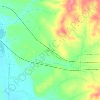
Name: Hickory Grove topographic map, elevation, terrain.

Location: Hickory Grove, Carroll County, Illinois, United States (42.03975 -90.08763 42.07975 -90.04763)

Average elevation: 699 ft

Minimum elevation: 574 ft

Maximum elevation: 889 ft

Carroll County trails, hiking, mountain biking, running and outdoor activities

Other topographic maps

Click on a map to view its topography, its elevation and its terrain.

Lake Carroll

United States > Illinois > Carroll County

Average elevation: 810 ft

Mount Carroll

United States > Illinois > Carroll County

Due to its elevation and northwesterly location, Mount Carroll is subject to unusually cold winter weather. From 1930 to 1999, Mount Carroll held the record for the lowest temperature ever recorded in Illinois, −35 °F (−37 °C), recorded on January 22, 1930. The record was beaten by Congerville in 1999,…

Average elevation: 791 ft

Chadwick

United States > Illinois > Carroll County

Average elevation: 781 ft

Milledgeville

United States > Illinois > Carroll County

Average elevation: 758 ft

Shannon

United States > Illinois > Carroll County

Average elevation: 928 ft

Thomson

United States > Illinois > Carroll County

Average elevation: 600 ft

Lanark

United States > Illinois > Carroll County

Average elevation: 846 ft

Gear up for your next adventure:

🧭Map Reading Tools - Tools and kits for map navigation
🚁Photography Drones - Capture stunning aerial views of landforms and topography
🦶Carbon Trekking Poles - Reduce knee impact on steep descents with ultra-light poles
🧤Hiking Gloves - Protective gloves for rugged trails
🪶Multi‑Purpose Knife - Useful blade for camp and trail

As an Amazon Associate, this site earns from qualifying purchases at no extra cost to you.