
Três Rios topographic map
Click on the map to display elevation.
About this map
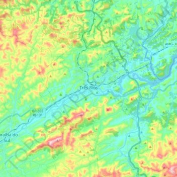
Name: Três Rios topographic map, elevation, terrain.
Average elevation: 1,243 ft
Minimum elevation: 830 ft
Maximum elevation: 2,283 ft
Other topographic maps
Click on a map to view its topography, its elevation and its terrain.
Barra da Tijuca
Brazil > Rio de Janeiro > Região Metropolitana do Rio de Janeiro > Rio de Janeiro
Average elevation: 13 ft
Armação dos Búzios
Brazil > Rio de Janeiro > Armação dos Búzios > Armação dos Búzios
Average elevation: 16 ft
Praia do Leblon
Brazil > Rio de Janeiro > Região Metropolitana do Rio de Janeiro > Rio de Janeiro
Average elevation: 85 ft
Morro do Pinto
Brazil > Rio de Janeiro > Região Metropolitana do Rio de Janeiro > Rio de Janeiro
Average elevation: 36 ft
Rio Cuiabá
Brazil > Rio de Janeiro > Região Metropolitana do Rio de Janeiro > Petrópolis
Average elevation: 3,038 ft
Praça Jamal de Paula
Brazil > Rio de Janeiro > Região Metropolitana do Rio de Janeiro > Rio de Janeiro
Average elevation: 92 ft