Geolocate

Graceham topographic map

Click on the map to display elevation.

About this map

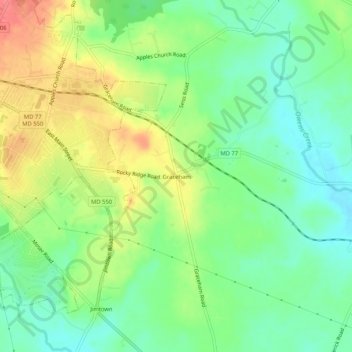
Name: Graceham topographic map, elevation, terrain.

Location: Graceham, Frederick County, Maryland, 21788, United States (39.59427 -77.40165 39.63427 -77.36165)

Average elevation: 430 ft

Minimum elevation: 335 ft

Maximum elevation: 564 ft

Frederick County trails, hiking, mountain biking, running and outdoor activities

Other topographic maps

Click on a map to view its topography, its elevation and its terrain.

Woodsboro

United States > Maryland > Frederick County

Average elevation: 404 ft

New Market

United States > Maryland > Frederick County

Average elevation: 499 ft

Clover Hill

United States > Maryland > Frederick County

Average elevation: 364 ft

Burkittsville

United States > Maryland > Frederick County

Average elevation: 610 ft

Rosemont

United States > Maryland > Frederick County

Average elevation: 449 ft

Green Valley

United States > Maryland > Frederick County

Average elevation: 505 ft

Flat Run

United States > Maryland > Frederick County > Emmitsburg

Average elevation: 453 ft

Gear up for your next adventure:

🛰️Handheld GPS Units - Professional satellite navigators for precise backcountry mapping
🛡️Bear Spray Outdoor - Protection in bear country hikes
🥾Men's Hiking Boots - Durable, waterproof footwear for rugged terrain and steep inclines
🏕️Family Camping Gear - Essentials for group camping trips
🔭Telescopic Hiking Pole - Adjustable pole for hiking stability

As an Amazon Associate, this site earns from qualifying purchases at no extra cost to you.