Geolocate

Lican topographic map

Click on the map to display elevation.

About this map

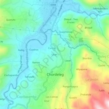
Name: Lican topographic map, elevation, terrain.

Location: Lican, Chordeleg, Azuay, 010350, Ecuador (-2.93496 -78.79640 -2.89496 -78.75640)

Average elevation: 7,769 ft

Minimum elevation: 7,306 ft

Maximum elevation: 8,957 ft

Gear up for your next adventure:

🪶Compact Camp Shovel - Folding shovel for campsite tasks
🔭Telescopic Hiking Pole - Adjustable pole for hiking stability
🪑Portable Camp Table - Compact table for campsite meals
🔭Stargazing Telescopes - Perfect for camping in low-light pollution areas shown on maps
🕶️GPS Smartphone Mount - Secure mount for phone navigation

As an Amazon Associate, this site earns from qualifying purchases at no extra cost to you.