
Make a donation
Gear up for your next adventure:
As an Amazon Associate, this site earns from qualifying purchases at no extra cost to you.
Schauernheim topographic map
Click on the map to display elevation.
Make a donation
Gear up for your next adventure:
As an Amazon Associate, this site earns from qualifying purchases at no extra cost to you.
About this map
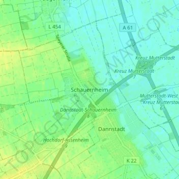
Name: Schauernheim topographic map, elevation, terrain.
Average elevation: 328 ft
Minimum elevation: 305 ft
Maximum elevation: 361 ft
Make a donation
Gear up for your next adventure:
As an Amazon Associate, this site earns from qualifying purchases at no extra cost to you.
Other topographic maps
Click on a map to view its topography, its elevation and its terrain.
Dannstadt
Deutschland > Rheinland-Pfalz > Rhein-Pfalz-Kreis > Dannstadt-Schauernheim
Vor Ort existieren insgesamt 24 Objekte, die unter Denkmalschutz stehen. Seit 1988 findet vor Ort der Mundartwettbewerb Dannstadter Höhe statt. Im Südosten der Gemarkung befindet sich mit dem Gräberfeld bei Dannstadt ein Naturschutzgebiet.
Average elevation: 331 ft