Geolocate

Ashford topographic map

Click on the map to display elevation.

About this map

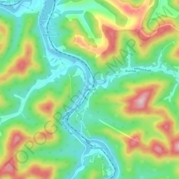
Name: Ashford topographic map, elevation, terrain.

Location: Ashford, Boone County, West Virginia, 25009, United States (38.15927 -81.73096 38.19927 -81.69096)

Average elevation: 971 ft

Minimum elevation: 620 ft

Maximum elevation: 1,542 ft

Boone County trails, hiking, mountain biking, running and outdoor activities

Other topographic maps

Click on a map to view its topography, its elevation and its terrain.

Whitesville

United States > West Virginia > Boone County

Average elevation: 1,352 ft

Madison

United States > West Virginia > Boone County

Average elevation: 1,066 ft

Danville

United States > West Virginia > Boone County

Average elevation: 919 ft

Sylvester

United States > West Virginia > Boone County

Average elevation: 1,266 ft

Gear up for your next adventure:

🪶Wildlife Field Guides - Learn animal tracking and species ID
📻Weather Alert Radios - Stay informed of storm risks while off-the-grid
🍳Camping Cook Set - Complete cookware for outdoor meals
🌧️Backpack Rain Cover - Keep gear dry in wet weather
🧦Hiking Socks - Comfortable socks to prevent blisters on long hikes

As an Amazon Associate, this site earns from qualifying purchases at no extra cost to you.