Geolocate

Springfield topographic map

Click on the map to display elevation.

About this map

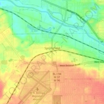
Name: Springfield topographic map, elevation, terrain.

Location: Springfield, Calhoun County, Michigan, 49037, United States (42.31192 -85.27511 42.33735 -85.20946)

Average elevation: 879 ft

Minimum elevation: 791 ft

Maximum elevation: 961 ft

Calhoun County trails, hiking, mountain biking, running and outdoor activities

Other topographic maps

Click on a map to view its topography, its elevation and its terrain.

Albion Landing

United States > Michigan > Calhoun County

Average elevation: 951 ft

White Lake

United States > Michigan > Calhoun County

Average elevation: 942 ft

Ceresco

United States > Michigan > Calhoun County

Average elevation: 909 ft

East Leroy

United States > Michigan > Calhoun County

Average elevation: 922 ft

Marengo

United States > Michigan > Calhoun County

Average elevation: 961 ft

Eckford

United States > Michigan > Calhoun County

Average elevation: 974 ft

Pennfield

United States > Michigan > Calhoun County

Average elevation: 869 ft

Clarendon

United States > Michigan > Calhoun County

Average elevation: 981 ft

Bedford

United States > Michigan > Calhoun County

Average elevation: 896 ft

Gear up for your next adventure:

👖Convertible Hiking Pants - Versatile zip-off pants for changing altitudes and temperatures
🎒Waterproof Dry Bags - Keep your electronics and maps dry inside your pack
🛌Ultralight Sleeping Bags - Compact down bags for cold nights in the wilderness
🧥Men's Rain Shells - Premium waterproof and breathable jackets for mountain weather
📡Handheld GPS Device - Reliable handheld GPS for outdoor navigation

As an Amazon Associate, this site earns from qualifying purchases at no extra cost to you.