
Innertkirchen topographic map
Click on the map to display elevation.
Innertkirchen
The large alpine municipality is located at the confluence of the Urbach and Gadmer streams into the Aare river. It includes the Urbach valley, the Gadmen valley, the Gen valley, the Wetterhorn mountain and the Gauli Glacier. Innertkirchen was created out of the Bäuerten (farming communities) of Grund, Bottigen, Wyler-Schattseite, Wyler-Sonnseite and the agricultural cooperative of Äppigen in 1834. The merger with Gadmen almost doubled the size the municipality. Gadmen lies in the Bernese Oberland with the Susten Pass on the eastern border of the former municipality. The municipal borders stretch from the valley floor, with an elevation of 850–1,250 m (2,790–4,100 ft), up to the nearby mountain peaks at about 3,500 m (11,500 ft). It is located on the border of the Canton of Bern with the Cantons of Obwalden, Nidwalden, Uri and Valais.
About this map
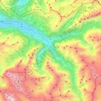
Name: Innertkirchen topographic map, elevation, terrain.
Average elevation: 6,381 ft
Minimum elevation: 1,870 ft
Maximum elevation: 13,199 ft
Other topographic maps
Click on a map to view its topography, its elevation and its terrain.
Windegghoren
Switzerland > Bern > Interlaken-Oberhasli administrative district > Innertkirchen
Average elevation: 7,470 ft
Triftsee
Switzerland > Bern > Interlaken-Oberhasli administrative district > Innertkirchen
Average elevation: 6,644 ft
Underburg
Switzerland > Bern > Interlaken-Oberhasli administrative district > Innertkirchen > Wychel
Average elevation: 2,992 ft
Wychel
Switzerland > Bern > Interlaken-Oberhasli administrative district > Innertkirchen
Average elevation: 3,255 ft
Underburg
Switzerland > Bern > Interlaken-Oberhasli administrative district > Innertkirchen > Wychel
Average elevation: 2,992 ft
Spis
Switzerland > Bern > Interlaken-Oberhasli administrative district > Innertkirchen > Äppigen
Average elevation: 2,858 ft