
Make a donation
Gear up for your next adventure:
As an Amazon Associate, this site earns from qualifying purchases at no extra cost to you.
Brooks topographic map
Click on the map to display elevation.
Make a donation
Gear up for your next adventure:
As an Amazon Associate, this site earns from qualifying purchases at no extra cost to you.
About this map
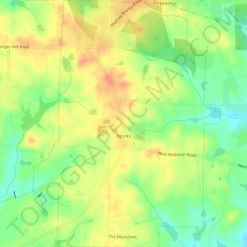
Name: Brooks topographic map, elevation, terrain.
Location: Brooks, Fayette County, Georgia, United States (33.27285 -84.47709 33.31304 -84.44067)
Average elevation: 820 ft
Minimum elevation: 741 ft
Maximum elevation: 889 ft
Fayette County trails, hiking, mountain biking, running and outdoor activities
Make a donation
Gear up for your next adventure:
As an Amazon Associate, this site earns from qualifying purchases at no extra cost to you.
Other topographic maps
Click on a map to view its topography, its elevation and its terrain.
Make a donation
Gear up for your next adventure:
As an Amazon Associate, this site earns from qualifying purchases at no extra cost to you.
Burnham Woods
United States > Georgia > Fayette County > Peachtree City > Burnham Woods
Average elevation: 837 ft