
Make a donation
Gear up for your next adventure:
As an Amazon Associate, this site earns from qualifying purchases at no extra cost to you.
Unterriexingen topographic map
Click on the map to display elevation.
Make a donation
Gear up for your next adventure:
As an Amazon Associate, this site earns from qualifying purchases at no extra cost to you.
Unterriexingen
Zu Unterriexingen gehören außerdem Gebäude auf dem Hohberg, die Frauenkirche auf der Höhe südwestlich des Ortes und Aussiedlerhöfe im Westen.
Make a donation
Gear up for your next adventure:
As an Amazon Associate, this site earns from qualifying purchases at no extra cost to you.
About this map
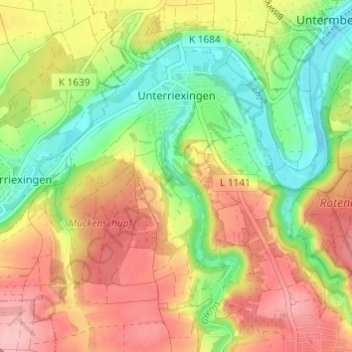
Name: Unterriexingen topographic map, elevation, terrain.
Average elevation: 820 ft
Minimum elevation: 604 ft
Maximum elevation: 1,043 ft
Make a donation
Gear up for your next adventure:
As an Amazon Associate, this site earns from qualifying purchases at no extra cost to you.
Other topographic maps
Click on a map to view its topography, its elevation and its terrain.
Aichholzhof
Deutschland > Baden-Württemberg > Landkreis Ludwigsburg > Markgröningen > Aichholzhof
Average elevation: 938 ft