
Make a donation
Gear up for your next adventure:
As an Amazon Associate, this site earns from qualifying purchases at no extra cost to you.
Montbenoît topographic map
Click on the map to display elevation.
Make a donation
Gear up for your next adventure:
As an Amazon Associate, this site earns from qualifying purchases at no extra cost to you.
Montbenoît
Située à 783 m d'altitude en aval (au niveau de la départementale qui relie Pontarlier à Morteau), à 850 m au niveau de sa partie Nord et à 14 km au Nord-Est de la ville de Pontarlier, le village est situé sur la rive gauche du Doubs, au creux du Val du Sauget. La commune occupe 5,1 km2 (503 ha dont 338 ha de bois) et compte un peu plus de 200 habitants.
Make a donation
Gear up for your next adventure:
As an Amazon Associate, this site earns from qualifying purchases at no extra cost to you.
About this map
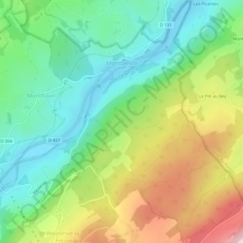
Name: Montbenoît topographic map, elevation, terrain.
Average elevation: 3,048 ft
Minimum elevation: 2,543 ft
Maximum elevation: 3,924 ft
Make a donation
Gear up for your next adventure:
As an Amazon Associate, this site earns from qualifying purchases at no extra cost to you.
Other topographic maps
Click on a map to view its topography, its elevation and its terrain.
Les Picardes
France > Bourgogne-Franche-Comté > Doubs > Pays-de-Montbenoît
Average elevation: 2,959 ft
Les Courtots
France > Bourgogne-Franche-Comté > Doubs > Pays-de-Montbenoît
Average elevation: 2,933 ft