
Make a donation
Gear up for your next adventure:
As an Amazon Associate, this site earns from qualifying purchases at no extra cost to you.
Malad River topographic map
Click on the map to display elevation.
Make a donation
Gear up for your next adventure:
As an Amazon Associate, this site earns from qualifying purchases at no extra cost to you.
About this map
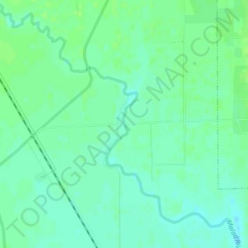
Name: Malad River topographic map, elevation, terrain.
Location: Malad River, Box Elder County, Utah, 84301, United States (41.60918 -112.14845 41.60931 -112.14839)
Average elevation: 4,249 ft
Minimum elevation: 4,229 ft
Maximum elevation: 4,265 ft
Make a donation
Gear up for your next adventure:
As an Amazon Associate, this site earns from qualifying purchases at no extra cost to you.
Other topographic maps
Click on a map to view its topography, its elevation and its terrain.
Brigham City
United States > Utah > Box Elder County
According to the United States Census Bureau, the city has a total area of 24.2 square miles (62.6 km2), of which 23.8 square miles (61.7 km2) is land and 0.35 square miles (0.9 km2), or 1.40%, is water. It lies at an elevation of 4,315 feet (1,315 m).
Average elevation: 5,016 ft
Make a donation
Gear up for your next adventure:
As an Amazon Associate, this site earns from qualifying purchases at no extra cost to you.
Make a donation
Gear up for your next adventure:
As an Amazon Associate, this site earns from qualifying purchases at no extra cost to you.
Brigham City
United States > Utah > Box Elder County
According to the United States Census Bureau, the city has a total area of 24.2 square miles (62.6 km2), of which 23.8 square miles (61.7 km2) is land and 0.35 square miles (0.9 km2), or 1.40%, is water. It lies at an elevation of 4,315 feet (1,315 m).
Average elevation: 5,016 ft
Make a donation
Gear up for your next adventure:
As an Amazon Associate, this site earns from qualifying purchases at no extra cost to you.