
Thank you for supporting this site ❤️
Make a donation
Make a donation
Gear up for your next adventure:
As an Amazon Associate, this site earns from qualifying purchases at no extra cost to you.
Tepeitic topographic map
Click on the map to display elevation.
Thank you for supporting this site ❤️
Make a donation
Make a donation
Gear up for your next adventure:
As an Amazon Associate, this site earns from qualifying purchases at no extra cost to you.
About this map
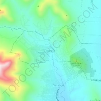
Name: Tepeitic topographic map, elevation, terrain.
Location: Tepeitic, Mixquiahuala de Juárez, Hidalgo, 42752, México (20.22086 -99.31063 20.26086 -99.27063)
Average elevation: 6,988 ft
Minimum elevation: 6,535 ft
Maximum elevation: 8,514 ft
Thank you for supporting this site ❤️
Make a donation
Make a donation
Gear up for your next adventure:
As an Amazon Associate, this site earns from qualifying purchases at no extra cost to you.