
Thank you for supporting this site ❤️
Make a donation
Make a donation
Gear up for your next adventure:
As an Amazon Associate, this site earns from qualifying purchases at no extra cost to you.
Nabeul topographic map
Click on the map to display elevation.
Thank you for supporting this site ❤️
Make a donation
Make a donation
Gear up for your next adventure:
As an Amazon Associate, this site earns from qualifying purchases at no extra cost to you.
About this map
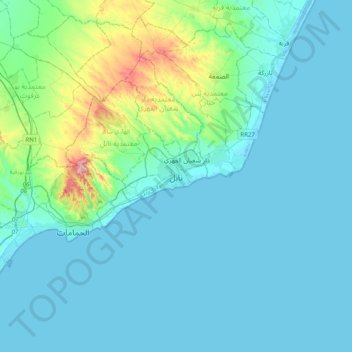
Name: Nabeul topographic map, elevation, terrain.
Location: Nabeul, الحدائق, معتمدية نابل, Nabeul, 8000, Tunisia (36.29129 10.57559 36.61129 10.89559)
Average elevation: 135 ft
Minimum elevation: -13 ft
Maximum elevation: 1,053 ft
Thank you for supporting this site ❤️
Make a donation
Make a donation
Gear up for your next adventure:
As an Amazon Associate, this site earns from qualifying purchases at no extra cost to you.