Geolocate

Along topographic map

Click on the map to display elevation.

About this map

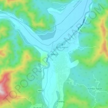
Name: Along topographic map, elevation, terrain.

Location: Along, Aalo HQ, West Siang, Arunachal Pradesh, India (28.12980 94.75854 28.20980 94.83854)

Average elevation: 1,266 ft

Minimum elevation: 702 ft

Maximum elevation: 3,504 ft

Gear up for your next adventure:

🥘Titanium Cookware - Durable, featherlight pots and pans for backpacking
🛡️Bear Spray Outdoor - Protection in bear country hikes
💧Water Purification System - Clean water on the trail with reliable purifiers
🪶Multi‑Purpose Knife - Useful blade for camp and trail
🏔️Mountain Trail Maps - High‑detail maps for popular peaks

As an Amazon Associate, this site earns from qualifying purchases at no extra cost to you.