
Thank you for supporting this site ❤️
Make a donation
Make a donation
Gear up for your next adventure:
As an Amazon Associate, this site earns from qualifying purchases at no extra cost to you.
Villamontes topographic map
Click on the map to display elevation.
Thank you for supporting this site ❤️
Make a donation
Make a donation
Gear up for your next adventure:
As an Amazon Associate, this site earns from qualifying purchases at no extra cost to you.
About this map
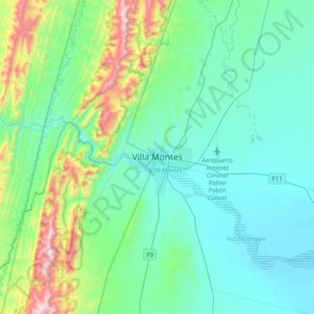
Name: Villamontes topographic map, elevation, terrain.
Location: Villamontes, Provincia Gran Chaco, Tarija, Bolivia (-21.41883 -63.63241 -21.09883 -63.31241)
Average elevation: 1,939 ft
Minimum elevation: 1,115 ft
Maximum elevation: 5,456 ft
Thank you for supporting this site ❤️
Make a donation
Make a donation
Gear up for your next adventure:
As an Amazon Associate, this site earns from qualifying purchases at no extra cost to you.