
Senenne topographic map
Click on the map to display elevation.
About this map
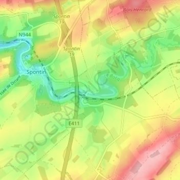
Name: Senenne topographic map, elevation, terrain.
Location: Senenne, Ciney, Dinant, Namur, Wallonie, Belgique (50.29847 5.00576 50.33847 5.04576)
Average elevation: 784 ft
Minimum elevation: 561 ft
Maximum elevation: 1,027 ft
Other topographic maps
Click on a map to view its topography, its elevation and its terrain.
Chevetogne
Belgique > Namur > Dinant > Ciney
Chevetogne est situé à 19 km de Dinant et à 10 km de Ciney. Le point culminant est situé à Ronvaux à 317 mètres d'altitude (au lieu-dit le Tige de Ronvaux). Le sol est argilo-calcaire et schisteux. Le village compte 75 hectares de bois et est exclusivement agricole. Chevetogne est arrosé par l'Iwoigne,…
Average elevation: 925 ft