Geolocate

Exeter topographic map

Click on the map to display elevation.

About this map

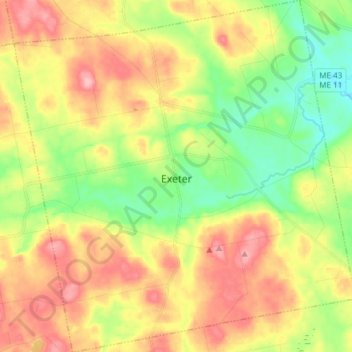
Name: Exeter topographic map, elevation, terrain.

Location: Exeter, Penobscot County, Maine, 04435, United States (44.91078 -69.20852 45.01740 -69.06239)

Average elevation: 364 ft

Minimum elevation: 171 ft

Maximum elevation: 577 ft

Penobscot County trails, hiking, mountain biking, running and outdoor activities

Other topographic maps

Click on a map to view its topography, its elevation and its terrain.

Bangor Hill

United States > Maine > Penobscot County > Orono

Average elevation: 203 ft

Hudson Hill

United States > Maine > Penobscot County > Hudson

Average elevation: 253 ft

Sugar Island

United States > Maine > Penobscot County > Greenbush

Average elevation: 135 ft

Tiger Rips

United States > Maine > Penobscot County

Average elevation: 741 ft

Blackcap

United States > Maine > Penobscot County > Eddington

Average elevation: 571 ft

State Island

United States > Maine > Penobscot County

Average elevation: 482 ft

Lincoln

United States > Maine > Penobscot County > Lincoln

Average elevation: 272 ft

Gear up for your next adventure:

🧭GPS Watch Accessories - Bands and chargers for GPS watches
🛠️Backpacking Tool Kit - Essential toolkit for outdoor repairs
🔌Solar Panel Charger - Charge gear sustainably outdoors
💧Water Purification System - Clean water on the trail with reliable purifiers
🔭Telescopic Hiking Pole - Adjustable pole for hiking stability

As an Amazon Associate, this site earns from qualifying purchases at no extra cost to you.