
Make a donation
Gear up for your next adventure:
As an Amazon Associate, this site earns from qualifying purchases at no extra cost to you.
Matinicus Island topographic map
Click on the map to display elevation.
Make a donation
Gear up for your next adventure:
As an Amazon Associate, this site earns from qualifying purchases at no extra cost to you.
Matinicus Island
Matinicus Isle plantation is an archipelago located on the southeastern fringes of Penobscot Bay in the Gulf of Maine, part of the Atlantic Ocean. According to the United States Census Bureau, the plantation has a total area of 9.9 square miles (26 km2), of which 2.3 square miles (6.0 km2) is land and 7.6 square miles (20 km2) is water. Matinicus Island, the largest land mass in the archipelago, spans approximately 2 miles (3.2 km) in length and 1-mile (1.6 km) in width for an area of about 720 acres (290 ha). The elevation ranges from 0 to 100 feet (30.5 m). Matinicus Isle is located approximately 1 mile (1.6 km) north of Criehaven Isle.
Make a donation
Gear up for your next adventure:
As an Amazon Associate, this site earns from qualifying purchases at no extra cost to you.
About this map
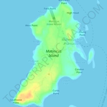
Name: Matinicus Island topographic map, elevation, terrain.
Average elevation: 16 ft
Minimum elevation: -3 ft
Maximum elevation: 108 ft
Knox County trails, hiking, mountain biking, running and outdoor activities
Make a donation
Gear up for your next adventure:
As an Amazon Associate, this site earns from qualifying purchases at no extra cost to you.