
Thank you for supporting this site ❤️
Make a donation
Make a donation
Gear up for your next adventure:
As an Amazon Associate, this site earns from qualifying purchases at no extra cost to you.
Singhat topographic map
Click on the map to display elevation.
Thank you for supporting this site ❤️
Make a donation
Make a donation
Gear up for your next adventure:
As an Amazon Associate, this site earns from qualifying purchases at no extra cost to you.
About this map
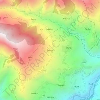
Name: Singhat topographic map, elevation, terrain.
Location: Singhat, Dadoli, Rudraprayag, Uttarakhand, 246421, India (30.39961 79.00488 30.43961 79.04488)
Average elevation: 4,469 ft
Minimum elevation: 2,575 ft
Maximum elevation: 6,634 ft
Thank you for supporting this site ❤️
Make a donation
Make a donation
Gear up for your next adventure:
As an Amazon Associate, this site earns from qualifying purchases at no extra cost to you.