
Thank you for supporting this site ❤️
Make a donation
Make a donation
Gear up for your next adventure:
As an Amazon Associate, this site earns from qualifying purchases at no extra cost to you.
El Manzano topographic map
Click on the map to display elevation.
Thank you for supporting this site ❤️
Make a donation
Make a donation
Gear up for your next adventure:
As an Amazon Associate, this site earns from qualifying purchases at no extra cost to you.
About this map
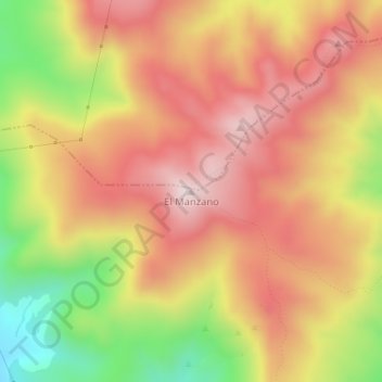
Name: El Manzano topographic map, elevation, terrain.
Average elevation: 2,671 ft
Minimum elevation: 1,732 ft
Maximum elevation: 3,314 ft
Thank you for supporting this site ❤️
Make a donation
Make a donation
Gear up for your next adventure:
As an Amazon Associate, this site earns from qualifying purchases at no extra cost to you.
Other topographic maps
Click on a map to view its topography, its elevation and its terrain.
Laguna Piedra Roja
Chile > Región Metropolitana de Santiago > Provincia de Chacabuco > Colina > Chicureo
Average elevation: 2,054 ft
Canal El Carmen
Chile > Región Metropolitana de Santiago > Provincia de Chacabuco > Colina > Los Jardines de Colina
Average elevation: 1,749 ft