
Make a donation
Gear up for your next adventure:
As an Amazon Associate, this site earns from qualifying purchases at no extra cost to you.
Feldberg topographic map
Click on the map to display elevation.
Make a donation
Gear up for your next adventure:
As an Amazon Associate, this site earns from qualifying purchases at no extra cost to you.
Feldberg
Der Feldberg liegt südöstlich von Freiburg im Breisgau, im Gebiet der Gemeinde Feldberg (Schwarzwald) im Landkreis Breisgau-Hochschwarzwald, umgeben von den Orten Hinterzarten (nordöstlich), Titisee (östlich), Menzenschwand und Bernau (südlich) sowie Todtnau (südwestlich). Rund zwei Kilometer südöstlich des Gipfels liegt in 1277 m Höhe der Ortsteil Feldberg-Ort.
Make a donation
Gear up for your next adventure:
As an Amazon Associate, this site earns from qualifying purchases at no extra cost to you.
About this map
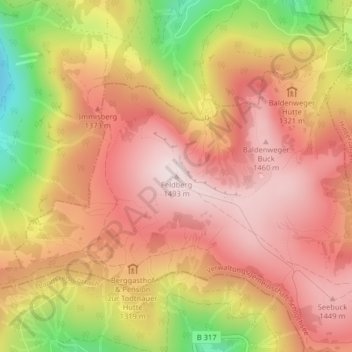
Name: Feldberg topographic map, elevation, terrain.
Average elevation: 4,236 ft
Minimum elevation: 3,084 ft
Maximum elevation: 4,908 ft
Make a donation
Gear up for your next adventure:
As an Amazon Associate, this site earns from qualifying purchases at no extra cost to you.
Other topographic maps
Click on a map to view its topography, its elevation and its terrain.
79868
Deutschland > Baden-Württemberg > Landkreis Breisgau-Hochschwarzwald > Feldberg (Ort)
Average elevation: 3,514 ft