
Make a donation
Gear up for your next adventure:
As an Amazon Associate, this site earns from qualifying purchases at no extra cost to you.
Vosges topographic map
Click on the map to display elevation.
Make a donation
Gear up for your next adventure:
As an Amazon Associate, this site earns from qualifying purchases at no extra cost to you.
Vosges
In addition, the term "Central Vosges" is used to designate the various lines of summits, especially those above 1,000 m (3,300 ft) in elevation. The French department of Vosges is named after the range.
Make a donation
Gear up for your next adventure:
As an Amazon Associate, this site earns from qualifying purchases at no extra cost to you.
About this map
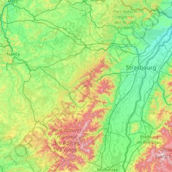
Name: Vosges topographic map, elevation, terrain.
Location: Vosges, Grand Est, Metropolitan France, France (47.69521 6.43908 49.12702 7.91222)
Average elevation: 1,171 ft
Minimum elevation: 354 ft
Maximum elevation: 4,826 ft
Make a donation
Gear up for your next adventure:
As an Amazon Associate, this site earns from qualifying purchases at no extra cost to you.
Other topographic maps
Click on a map to view its topography, its elevation and its terrain.
Make a donation
Gear up for your next adventure:
As an Amazon Associate, this site earns from qualifying purchases at no extra cost to you.
Make a donation
Gear up for your next adventure:
As an Amazon Associate, this site earns from qualifying purchases at no extra cost to you.
Make a donation
Gear up for your next adventure:
As an Amazon Associate, this site earns from qualifying purchases at no extra cost to you.
Falkenstein Castle
France > Grand Est > Moselle > Philippsbourg
In 1981, the Vosges Club (club vosgien) in Strasbourg placed a marker at the castle summit showing the altitude and directions to nearby land features.
Average elevation: 883 ft
Make a donation
Gear up for your next adventure:
As an Amazon Associate, this site earns from qualifying purchases at no extra cost to you.
Make a donation
Gear up for your next adventure:
As an Amazon Associate, this site earns from qualifying purchases at no extra cost to you.
Col du Platzerwasel
France > Grand Est > Haut-Rhin > Mittlach
The Col du Platzerwasel (elevation 1,182 m (3,878 ft)) is a mountain pass situated in the Vosges Mountains in the Haut-Rhin department of France, between Sondernach and Le Markstein. It has been crossed occasionally during the Tour de France cycle race, including on Stage 10 of the 2014 race.
Average elevation: 3,360 ft
Make a donation
Gear up for your next adventure:
As an Amazon Associate, this site earns from qualifying purchases at no extra cost to you.
Make a donation
Gear up for your next adventure:
As an Amazon Associate, this site earns from qualifying purchases at no extra cost to you.
Make a donation
Gear up for your next adventure:
As an Amazon Associate, this site earns from qualifying purchases at no extra cost to you.
Make a donation
Gear up for your next adventure:
As an Amazon Associate, this site earns from qualifying purchases at no extra cost to you.
Make a donation
Gear up for your next adventure:
As an Amazon Associate, this site earns from qualifying purchases at no extra cost to you.
Make a donation
Gear up for your next adventure:
As an Amazon Associate, this site earns from qualifying purchases at no extra cost to you.
Make a donation
Gear up for your next adventure:
As an Amazon Associate, this site earns from qualifying purchases at no extra cost to you.
Make a donation
Gear up for your next adventure:
As an Amazon Associate, this site earns from qualifying purchases at no extra cost to you.
Make a donation
Gear up for your next adventure:
As an Amazon Associate, this site earns from qualifying purchases at no extra cost to you.
Make a donation
Gear up for your next adventure:
As an Amazon Associate, this site earns from qualifying purchases at no extra cost to you.
Make a donation
Gear up for your next adventure:
As an Amazon Associate, this site earns from qualifying purchases at no extra cost to you.
Make a donation
Gear up for your next adventure:
As an Amazon Associate, this site earns from qualifying purchases at no extra cost to you.
La Trace
France > Grand Est > Haute-Marne > Roches-Bettaincourt > Bettaincourt-sur-Rognon
Average elevation: 889 ft
Make a donation
Gear up for your next adventure:
As an Amazon Associate, this site earns from qualifying purchases at no extra cost to you.
Make a donation
Gear up for your next adventure:
As an Amazon Associate, this site earns from qualifying purchases at no extra cost to you.
Make a donation
Gear up for your next adventure:
As an Amazon Associate, this site earns from qualifying purchases at no extra cost to you.
Make a donation
Gear up for your next adventure:
As an Amazon Associate, this site earns from qualifying purchases at no extra cost to you.
Le Markstein
France > Grand Est > Haut-Rhin > Fellering
Le Markstein is a winter sports station in the Vosges mountains in France situated at an altitude of between 1,020 m (3,346 ft) and 1,268 m (4,160 ft) which is located on the Route des Crêtes. It forms a set of cross-country skiing with the Breitfirst ski-station and the Grand Ballon. The highest point is the…
Average elevation: 3,323 ft
Make a donation
Gear up for your next adventure:
As an Amazon Associate, this site earns from qualifying purchases at no extra cost to you.
Make a donation
Gear up for your next adventure:
As an Amazon Associate, this site earns from qualifying purchases at no extra cost to you.
Make a donation
Gear up for your next adventure:
As an Amazon Associate, this site earns from qualifying purchases at no extra cost to you.
Quartier des Aviateurs
France > Grand Est > Bas-Rhin > Sélestat > Quartier des Aviateurs
Average elevation: 574 ft
Make a donation
Gear up for your next adventure:
As an Amazon Associate, this site earns from qualifying purchases at no extra cost to you.