
Make a donation
Gear up for your next adventure:
As an Amazon Associate, this site earns from qualifying purchases at no extra cost to you.
Bencoy topographic map
Click on the map to display elevation.
Make a donation
Gear up for your next adventure:
As an Amazon Associate, this site earns from qualifying purchases at no extra cost to you.
About this map
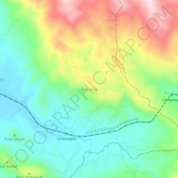
Name: Bencoy topographic map, elevation, terrain.
Location: Bencoy, Sukabumi, West Java, Java, Indonesia (-6.96860 107.02251 -6.92860 107.06251)
Average elevation: 2,290 ft
Minimum elevation: 1,857 ft
Maximum elevation: 3,038 ft
Make a donation
Gear up for your next adventure:
As an Amazon Associate, this site earns from qualifying purchases at no extra cost to you.
Other topographic maps
Click on a map to view its topography, its elevation and its terrain.
Mount Gede Pangrango National Park
Indonesia > West Java > Sukabumi > Kadudampit
Average elevation: 3,461 ft
Make a donation
Gear up for your next adventure:
As an Amazon Associate, this site earns from qualifying purchases at no extra cost to you.