Geolocate

Oosterbeek topographic map

Click on the map to display elevation.

About this map

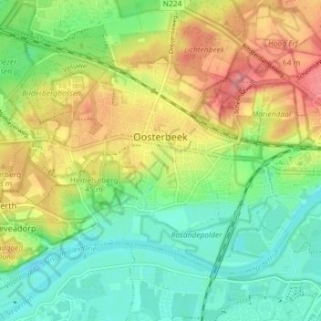
Name: Oosterbeek topographic map, elevation, terrain.

Location: Oosterbeek, Renkum, Gelderland, Netherlands (51.96951 5.79867 52.00081 5.87086)

Average elevation: 112 ft

Minimum elevation: 0 ft

Maximum elevation: 266 ft

Other topographic maps

Click on a map to view its topography, its elevation and its terrain.

Waterberg

Netherlands > Gelderland > Arnhem

Average elevation: 187 ft

Gear up for your next adventure:

🪶Camping Sleeping Pad - Comfortable sleeping pad for backpacking
🌡️Handheld Weather Meters - Measure wind, temp, and pressure for safe mountain travel
🧭Map Reading Tools - Tools and kits for map navigation
🧥Waterproof Jacket for Hiking - Breathable and rugged rain jacket for outdoor excursions
🧦Merino Wool Socks - Moisture-wicking, blister-preventing socks for long treks

As an Amazon Associate, this site earns from qualifying purchases at no extra cost to you.