
Make a donation
Gear up for your next adventure:
As an Amazon Associate, this site earns from qualifying purchases at no extra cost to you.
Ballée topographic map
Click on the map to display elevation.
Make a donation
Gear up for your next adventure:
As an Amazon Associate, this site earns from qualifying purchases at no extra cost to you.
Ballée
La commune est environnée de pâturages. Elle est arrosée par l'Erve, qui la traverse du nord au sud en la partageant en deux parties d'égale étendue. Son altitude culmine à 88 mètres vers le logis de Linières.
Make a donation
Gear up for your next adventure:
As an Amazon Associate, this site earns from qualifying purchases at no extra cost to you.
About this map
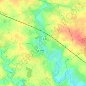
Name: Ballée topographic map, elevation, terrain.
Average elevation: 213 ft
Minimum elevation: 121 ft
Maximum elevation: 312 ft
Make a donation
Gear up for your next adventure:
As an Amazon Associate, this site earns from qualifying purchases at no extra cost to you.
Other topographic maps
Click on a map to view its topography, its elevation and its terrain.
Champ de l'Habit
France > Pays de la Loire > Mayenne > Val-du-Maine > L'Habit
Average elevation: 262 ft