
Make a donation
Gear up for your next adventure:
As an Amazon Associate, this site earns from qualifying purchases at no extra cost to you.
Lumaco topographic map
Click on the map to display elevation.
Make a donation
Gear up for your next adventure:
As an Amazon Associate, this site earns from qualifying purchases at no extra cost to you.
About this map
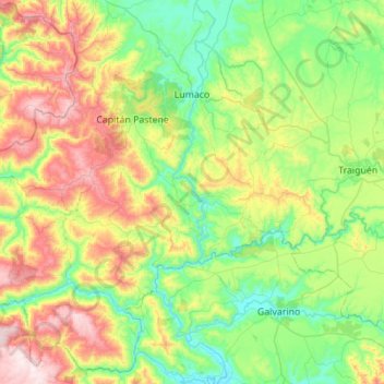
Name: Lumaco topographic map, elevation, terrain.
Average elevation: 909 ft
Minimum elevation: 79 ft
Maximum elevation: 2,766 ft
Make a donation
Gear up for your next adventure:
As an Amazon Associate, this site earns from qualifying purchases at no extra cost to you.
Other topographic maps
Click on a map to view its topography, its elevation and its terrain.
Villa Esperanza
Chile > Región de la Araucanía > Provincia de Malleco > Collipulli
Average elevation: 561 ft
Sierra Nevada
Chile > Región de la Araucanía > Provincia de Malleco > Lonquimay
El Sierra Nevada es un volcán ubicado en la IX Región de La Araucanía, Chile. Clasificado como estratovolcán, el Sierra Nevada tiene una altitud de 2554 m s. n. m., y se localiza en la zona precordillerana de La Frontera, cerca del volcán Llaima.
Average elevation: 7,188 ft
Make a donation
Gear up for your next adventure:
As an Amazon Associate, this site earns from qualifying purchases at no extra cost to you.
Comunidad Marileo
Chile > Región de la Araucanía > Provincia de Malleco > Victoria
Average elevation: 1,060 ft
Comunidad Domingo Imilqueo
Chile > Región de la Araucanía > Provincia de Malleco > Los Sauces
Average elevation: 781 ft
Río Malleco
Chile > Región de la Araucanía > Provincia de Malleco > Curacautín
Average elevation: 2,733 ft
Make a donation
Gear up for your next adventure:
As an Amazon Associate, this site earns from qualifying purchases at no extra cost to you.
Chacayal
Chile > Región de la Araucanía > Provincia de Malleco > Purén > Chacayal
Average elevation: 292 ft