
Make a donation
Gear up for your next adventure:
As an Amazon Associate, this site earns from qualifying purchases at no extra cost to you.
Aid topographic map
Click on the map to display elevation.
Make a donation
Gear up for your next adventure:
As an Amazon Associate, this site earns from qualifying purchases at no extra cost to you.
About this map
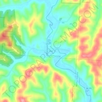
Name: Aid topographic map, elevation, terrain.
Average elevation: 722 ft
Minimum elevation: 561 ft
Maximum elevation: 971 ft
Make a donation
Gear up for your next adventure:
As an Amazon Associate, this site earns from qualifying purchases at no extra cost to you.
Other topographic maps
Click on a map to view its topography, its elevation and its terrain.
Proctorville
Vereinigte Staaten von Amerika > Ohio > Lawrence County
Das Dorf liegt im äußersten Süden von Ohio am nördlichen Ufer des Ohio Rivers in einer ehemaligen Flussaue. Die vorwiegend bewaldete Umgebung ist leicht hügelig und erreicht an einigen Punkten etwa 250 Meter Höhe. Zahlreiche Bäche fließen in südlicher Richtung in den Ohio River. Die Landnutzung wird…
Average elevation: 571 ft