Geolocate

Nivin topographic map

Click on the map to display elevation.

About this map

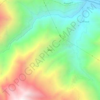
Name: Nivin topographic map, elevation, terrain.

Location: Nivin, Carhuaz, Áncash, 02127, Perú (-9.31548 -77.71072 -9.27548 -77.67072)

Average elevation: 10,535 ft

Minimum elevation: 8,409 ft

Maximum elevation: 13,825 ft

Gear up for your next adventure:

🔪Outdoor Multitools - Essential survival tools for gear repair and field use
🛏️Cold Weather Sleeping Bag - Warm sleeping bag for cold conditions
👓Polarized Sunglasses - Outdoor sunglasses for glare reduction
🔋Solar Power Banks - Keep your GPS and phone charged in remote wilderness areas
Backpacking Tent - Lightweight and durable tent for multi‑day hikes

As an Amazon Associate, this site earns from qualifying purchases at no extra cost to you.