Geolocate

Dobson Landing topographic map

Click on the map to display elevation.

About this map

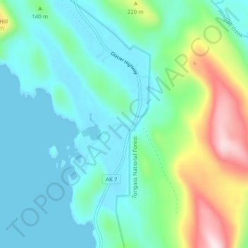
Name: Dobson Landing topographic map, elevation, terrain.

Location: Dobson Landing, Juneau, Alaska, United States (58.47578 -134.79337 58.51578 -134.75337)

Average elevation: 322 ft

Minimum elevation: -10 ft

Maximum elevation: 1,398 ft

Alaska trails, hiking, mountain biking, running and outdoor activities

Other topographic maps

Click on a map to view its topography, its elevation and its terrain.

Mendenhall Glacier

United States > Alaska > Juneau

Average elevation: 1,178 ft

Lemon Creek

United States > Alaska > Juneau

Average elevation: 1,414 ft

Lena Beach

United States > Alaska > Juneau > Lena Beach

Average elevation: 338 ft

West Juneau

United States > Alaska > Juneau

Average elevation: 361 ft

Gear up for your next adventure:

🔊Portable Camp Speaker - Music and alerts at camp
🧦Merino Wool Socks - Moisture-wicking, blister-preventing socks for long treks
🪵Folding Camp Saw - Compact saw for wood and campsite work
🪶Survival Guide Book - Expert advice for emergency preparedness
🧤Hiking Gloves - Protective gloves for rugged trails

As an Amazon Associate, this site earns from qualifying purchases at no extra cost to you.