
Make a donation
Gear up for your next adventure:
As an Amazon Associate, this site earns from qualifying purchases at no extra cost to you.
Cashel topographic map
Click on the map to display elevation.
Make a donation
Gear up for your next adventure:
As an Amazon Associate, this site earns from qualifying purchases at no extra cost to you.
Cashel
The Rock of Cashel, to which the town below owes its origin, is an isolated elevation of stratified limestone, rising abruptly from a broad and fertile plain called the Golden Vale. The top of this eminence is crowned by a group of remarkable ruins. Originally known as Fairy Hill, or Sid-Druim, the Rock was, in pagan times, the dun, or castle, of the ancient Eoghnacht Chiefs of Munster. In Gaelic, Caiseal denotes a circular stone fort and is the name of several places in Ireland. The "Book of Rights" suggests the name is derived from Cais-il, i.e. "tribute stone", because the Munster tribes paid tribute on the Rock. Here Corc, grandfather of Aengus Mac Natfraich, erected a fort. Cashel subsequently became the capital of Munster and, like Tara and Armagh, it was a celebrated court. At the time of St. Patrick, when Aengus ruled as king, Cashel claimed supremacy over all the royal duns of the province.
Make a donation
Gear up for your next adventure:
As an Amazon Associate, this site earns from qualifying purchases at no extra cost to you.
About this map
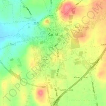
Name: Cashel topographic map, elevation, terrain.
Average elevation: 377 ft
Minimum elevation: 253 ft
Maximum elevation: 505 ft
Make a donation
Gear up for your next adventure:
As an Amazon Associate, this site earns from qualifying purchases at no extra cost to you.
Other topographic maps
Click on a map to view its topography, its elevation and its terrain.
Make a donation
Gear up for your next adventure:
As an Amazon Associate, this site earns from qualifying purchases at no extra cost to you.
Make a donation
Gear up for your next adventure:
As an Amazon Associate, this site earns from qualifying purchases at no extra cost to you.
Make a donation
Gear up for your next adventure:
As an Amazon Associate, this site earns from qualifying purchases at no extra cost to you.
Make a donation
Gear up for your next adventure:
As an Amazon Associate, this site earns from qualifying purchases at no extra cost to you.
Make a donation
Gear up for your next adventure:
As an Amazon Associate, this site earns from qualifying purchases at no extra cost to you.
Make a donation
Gear up for your next adventure:
As an Amazon Associate, this site earns from qualifying purchases at no extra cost to you.