
Make a donation
Gear up for your next adventure:
As an Amazon Associate, this site earns from qualifying purchases at no extra cost to you.
Calvi topographic map
Click on the map to display elevation.
Make a donation
Gear up for your next adventure:
As an Amazon Associate, this site earns from qualifying purchases at no extra cost to you.
Calvi
Il suo territorio è compreso tra un'altitudine di 169 e 388 m s.l.m., pari ad un'escursione altimetrica di 219 m.
Make a donation
Gear up for your next adventure:
As an Amazon Associate, this site earns from qualifying purchases at no extra cost to you.
About this map
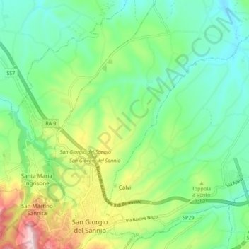
Name: Calvi topographic map, elevation, terrain.
Location: Calvi, Benevento, Campania, 82018, Italia (41.05879 14.85883 41.11713 14.94343)
Average elevation: 991 ft
Minimum elevation: 617 ft
Maximum elevation: 1,814 ft
Make a donation
Gear up for your next adventure:
As an Amazon Associate, this site earns from qualifying purchases at no extra cost to you.
Other topographic maps
Click on a map to view its topography, its elevation and its terrain.
Make a donation
Gear up for your next adventure:
As an Amazon Associate, this site earns from qualifying purchases at no extra cost to you.