
Make a donation
Gear up for your next adventure:
As an Amazon Associate, this site earns from qualifying purchases at no extra cost to you.
La Pierre Saint-Martin topographic map
Click on the map to display elevation.
Make a donation
Gear up for your next adventure:
As an Amazon Associate, this site earns from qualifying purchases at no extra cost to you.
La Pierre Saint-Martin
C'est une station familiale, un village de chalets, situé dans une forêt de pins. Le domaine propose 55 hectares, à 2 200 mètres d'altitude. Elle fait partie du regroupement de stations N'PY.
Make a donation
Gear up for your next adventure:
As an Amazon Associate, this site earns from qualifying purchases at no extra cost to you.
About this map
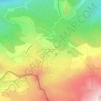
Name: La Pierre Saint-Martin topographic map, elevation, terrain.
Average elevation: 5,413 ft
Minimum elevation: 3,517 ft
Maximum elevation: 7,513 ft
Make a donation
Gear up for your next adventure:
As an Amazon Associate, this site earns from qualifying purchases at no extra cost to you.
Other topographic maps
Click on a map to view its topography, its elevation and its terrain.