
Make a donation
Gear up for your next adventure:
As an Amazon Associate, this site earns from qualifying purchases at no extra cost to you.
Contres topographic map
Click on the map to display elevation.
Make a donation
Gear up for your next adventure:
As an Amazon Associate, this site earns from qualifying purchases at no extra cost to you.
About this map
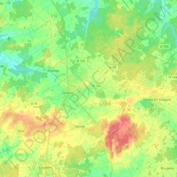
Name: Contres topographic map, elevation, terrain.
Average elevation: 351 ft
Minimum elevation: 272 ft
Maximum elevation: 456 ft
Make a donation
Gear up for your next adventure:
As an Amazon Associate, this site earns from qualifying purchases at no extra cost to you.
Other topographic maps
Click on a map to view its topography, its elevation and its terrain.
Abbaye de Cornilly
France > Centre-Val de Loire > Loir-et-Cher > Le Controis-en-Sologne
Average elevation: 364 ft
La Garde
France > Centre-Val de Loire > Loir-et-Cher > Le Controis-en-Sologne
Average elevation: 348 ft
Le Controis en Sologne
France > Centre-Val de Loire > Loir-et-Cher > Le Controis-en-Sologne
Average elevation: 341 ft
Peraclos
France > Centre-Val de Loire > Loir-et-Cher > Le Controis-en-Sologne > Les Aunaux
Average elevation: 312 ft
Make a donation
Gear up for your next adventure:
As an Amazon Associate, this site earns from qualifying purchases at no extra cost to you.
L'Ormeau Pouilleux
France > Centre-Val de Loire > Loir-et-Cher > Le Controis-en-Sologne
Average elevation: 338 ft
Coulomme
France > Centre-Val de Loire > Loir-et-Cher > Le Controis-en-Sologne > Coulomnes
Average elevation: 305 ft