Geolocate

帮达镇 topographic map

Interactive map

Click on the map to display elevation.

About this map

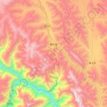
Name: 帮达镇 topographic map, elevation, terrain.

Location: 帮达镇, 八宿县, 昌都市, 西藏自治区, 中国 (30.03502 97.07161 30.33262 97.38647)

Average elevation: 14,114 ft

Minimum elevation: 8,796 ft

Maximum elevation: 17,956 ft

Other topographic maps

Click on a map to view its topography, its elevation and its terrain.

拉根乡

中国 > 西藏自治区 > 八宿县

拉根乡, 八宿县, 昌都市, 西藏自治区, 中国

Average elevation: 14,009 ft

瓦乡

中国 > 西藏自治区 > 八宿县

瓦乡, 八宿县, 昌都市, 西藏自治区, 中国

Average elevation: 15,663 ft

然乌镇

中国 > 西藏自治区 > 八宿县

然乌镇, 八宿县, 昌都市, 西藏自治区, 中国

Average elevation: 15,909 ft

益庆乡

中国 > 西藏自治区 > 八宿县

益庆乡, 八宿县, 昌都市, 西藏自治区, 中国

Average elevation: 15,518 ft

然乌湖

中国 > 西藏自治区 > 八宿县

然乌湖, 八宿县, 昌都市, 西藏自治区, 中国

Average elevation: 13,921 ft