
Make a donation
Gear up for your next adventure:
As an Amazon Associate, this site earns from qualifying purchases at no extra cost to you.
Jacques-Cartier topographic map
Click on the map to display elevation.
Make a donation
Gear up for your next adventure:
As an Amazon Associate, this site earns from qualifying purchases at no extra cost to you.
About this map
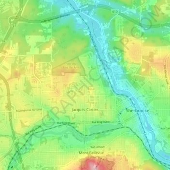
Name: Jacques-Cartier topographic map, elevation, terrain.
Location: Jacques-Cartier, Sherbrooke, Estrie, Québec, Canada (45.38410 -71.98523 45.44244 -71.88987)
Average elevation: 669 ft
Minimum elevation: 443 ft
Maximum elevation: 1,083 ft
Make a donation
Gear up for your next adventure:
As an Amazon Associate, this site earns from qualifying purchases at no extra cost to you.
Other topographic maps
Click on a map to view its topography, its elevation and its terrain.
Sherbrooke
Canada > Québec > Sherbrooke
Le territoire sherbrookois est situé dans une région vallonnée, faisant partie de la chaîne des Appalaches. Ce territoire accidenté est mouillé par quatre rivières, soit la Saint-François, la Magog, la Massawippi, la rivière aux Saumons, ainsi que par une importante étendue d’eau; le lac Magog. La…
Average elevation: 817 ft
Make a donation
Gear up for your next adventure:
As an Amazon Associate, this site earns from qualifying purchases at no extra cost to you.