
Thank you for supporting this site ❤️
Make a donation
Make a donation
Gear up for your next adventure:
As an Amazon Associate, this site earns from qualifying purchases at no extra cost to you.
Mokila topographic map
Click on the map to display elevation.
Thank you for supporting this site ❤️
Make a donation
Make a donation
Gear up for your next adventure:
As an Amazon Associate, this site earns from qualifying purchases at no extra cost to you.
About this map
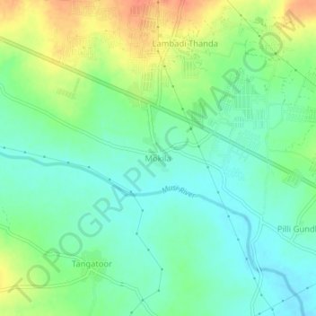
Name: Mokila topographic map, elevation, terrain.
Location: Mokila, Shankarpalle mandal, Ranga Reddy, Telangana, India (17.40632 78.16810 17.44632 78.20810)
Average elevation: 1,867 ft
Minimum elevation: 1,808 ft
Maximum elevation: 1,972 ft
Thank you for supporting this site ❤️
Make a donation
Make a donation
Gear up for your next adventure:
As an Amazon Associate, this site earns from qualifying purchases at no extra cost to you.