
Thank you for supporting this site ❤️
Make a donation
Make a donation
Gear up for your next adventure:
As an Amazon Associate, this site earns from qualifying purchases at no extra cost to you.
Rolfe topographic map
Click on the map to display elevation.
Thank you for supporting this site ❤️
Make a donation
Make a donation
Gear up for your next adventure:
As an Amazon Associate, this site earns from qualifying purchases at no extra cost to you.
About this map
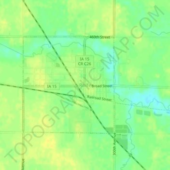
Name: Rolfe topographic map, elevation, terrain.
Location: Rolfe, Pocahontas County, Iowa, 50581, United States (42.80518 -94.54119 42.82055 -94.52143)
Average elevation: 1,184 ft
Minimum elevation: 1,145 ft
Maximum elevation: 1,211 ft
Pocahontas County trails, hiking, mountain biking, running and outdoor activities
Thank you for supporting this site ❤️
Make a donation
Make a donation
Gear up for your next adventure:
As an Amazon Associate, this site earns from qualifying purchases at no extra cost to you.