
Make a donation
Gear up for your next adventure:
As an Amazon Associate, this site earns from qualifying purchases at no extra cost to you.
Sarnadas de Ródão topographic map
Click on the map to display elevation.
Make a donation
Gear up for your next adventure:
As an Amazon Associate, this site earns from qualifying purchases at no extra cost to you.
About this map
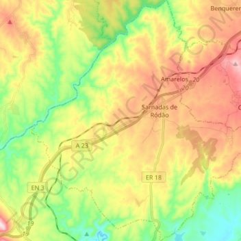
Name: Sarnadas de Ródão topographic map, elevation, terrain.
Average elevation: 955 ft
Minimum elevation: 364 ft
Maximum elevation: 1,578 ft
Make a donation
Gear up for your next adventure:
As an Amazon Associate, this site earns from qualifying purchases at no extra cost to you.
Other topographic maps
Click on a map to view its topography, its elevation and its terrain.
Make a donation
Gear up for your next adventure:
As an Amazon Associate, this site earns from qualifying purchases at no extra cost to you.
Barragem Romana da Lameira
Portugal > Castelo Branco > Vila Velha de Ródão > Perais
Average elevation: 627 ft
Make a donation
Gear up for your next adventure:
As an Amazon Associate, this site earns from qualifying purchases at no extra cost to you.
Albufeira de Fratel
Portugal > Castelo Branco > Vila Velha de Ródão > Fratel
Average elevation: 574 ft
Gavião do Ródão
Portugal > Castelo Branco > Vila Velha de Ródão > Gavião do Ródão
Average elevation: 856 ft
Make a donation
Gear up for your next adventure:
As an Amazon Associate, this site earns from qualifying purchases at no extra cost to you.