Geolocate

Waikane topographic map

Click on the map to display elevation.

About this map

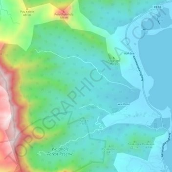
Name: Waikane topographic map, elevation, terrain.

Location: Waikane, Kailua, Honolulu County, Hawaii, United States (21.46825 -157.89625 21.51391 -157.84271)

Average elevation: 623 ft

Minimum elevation: -16 ft

Maximum elevation: 2,720 ft

Honolulu County trails, hiking, mountain biking, running and outdoor activities

Other topographic maps

Click on a map to view its topography, its elevation and its terrain.

Lanikai Beach

United States > Hawaii > Honolulu County > Kailua

Average elevation: 52 ft

Gear up for your next adventure:

🥾Hiking Shoes - Durable and comfortable shoes for trail hiking
🔥Plasma Lighters - Windproof lighters that work in any weather condition
🪄Magnetic Compass - Accurate compass for navigation
📱Heavy-Duty Phone Cases - Drop-proof and waterproof protection for outdoor navigation
🧭Orienteering Set - Complete compass and map reading kit

As an Amazon Associate, this site earns from qualifying purchases at no extra cost to you.