
Pincebec topographic map
Click on the map to display elevation.
About this map
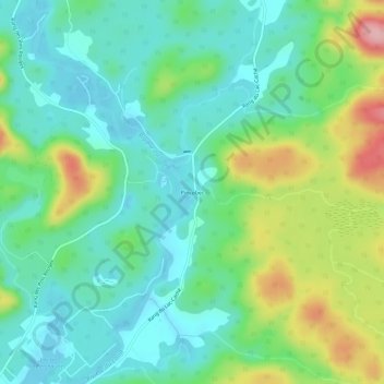
Name: Pincebec topographic map, elevation, terrain.
Average elevation: 663 ft
Minimum elevation: 509 ft
Maximum elevation: 1,017 ft
Other topographic maps
Click on a map to view its topography, its elevation and its terrain.
Lac aux Écorces
Canada > Québec > Maskinongé (MRC) > Saint-Alexis-des-Monts
Average elevation: 1,312 ft
Lac du Soufflet
Canada > Québec > Maskinongé (MRC) > Saint-Alexis-des-Monts
Average elevation: 1,266 ft
Lac à la Perchaude
Canada > Québec > Maskinongé (MRC) > Saint-Alexis-des-Monts
Average elevation: 745 ft
Rivière Matawin
Canada > Québec > Maskinongé (MRC) > Saint-Alexis-des-Monts
Average elevation: 1,345 ft
Lac à la Coureuse
Canada > Québec > Maskinongé (MRC) > Saint-Alexis-des-Monts
Average elevation: 915 ft