Geolocate

Paderne topographic map

Click on the map to display elevation.

About this map

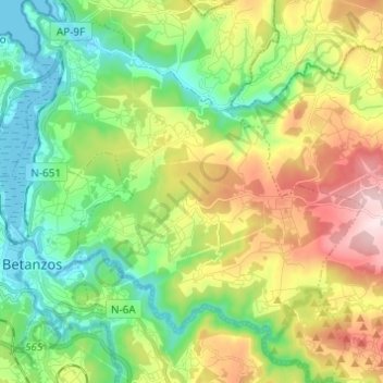
Name: Paderne topographic map, elevation, terrain.

Location: Paderne, Betanzos, A Coruña, Galicia, 15314, Spain (43.25176 -8.21699 43.34051 -8.10543)

Average elevation: 584 ft

Minimum elevation: -3 ft

Maximum elevation: 1,575 ft

Other topographic maps

Click on a map to view its topography, its elevation and its terrain.

Quistilan

Spain > Galicia > Betanzos

Average elevation: 554 ft

Burricios

Spain > Galicia > Betanzos > Oza-Cesuras

Average elevation: 876 ft

Tiúlfe

Spain > Galicia > Betanzos

Average elevation: 928 ft

Ansimonde

Spain > Galicia > Betanzos > Miño

Average elevation: 492 ft

As Brañas

Spain > Galicia > Betanzos > O Pazo de Irixoa

Average elevation: 1,243 ft

Cendá

Spain > Galicia > Betanzos

Average elevation: 817 ft

Cesuras

Spain > Galicia > Betanzos

Average elevation: 1,043 ft

Miño

Spain > Galicia > Betanzos

Average elevation: 135 ft

Gear up for your next adventure:

🧯Portable Fire Pit - Compact fire pit for camping spots
🚁Photography Drones - Capture stunning aerial views of landforms and topography
Backpacking Tents - Weight-optimized shelters for multi-day topographic surveys
🧦Merino Wool Socks - Moisture-wicking, blister-preventing socks for long treks
🔦Compact Flashlight - Reliable flashlight for emergencies

As an Amazon Associate, this site earns from qualifying purchases at no extra cost to you.