
Thank you for supporting this site ❤️
Make a donation
Make a donation
Gear up for your next adventure:
As an Amazon Associate, this site earns from qualifying purchases at no extra cost to you.
Nyalindung topographic map
Click on the map to display elevation.
Thank you for supporting this site ❤️
Make a donation
Make a donation
Gear up for your next adventure:
As an Amazon Associate, this site earns from qualifying purchases at no extra cost to you.
About this map
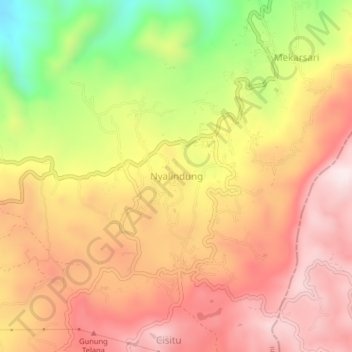
Name: Nyalindung topographic map, elevation, terrain.
Location: Nyalindung, Sukabumi, West Java, Java, 43265, Indonesia (-7.05214 106.92287 -7.01214 106.96287)
Average elevation: 2,854 ft
Minimum elevation: 1,722 ft
Maximum elevation: 3,619 ft
Thank you for supporting this site ❤️
Make a donation
Make a donation
Gear up for your next adventure:
As an Amazon Associate, this site earns from qualifying purchases at no extra cost to you.