Geolocate

Yuma topographic map

Click on the map to display elevation.

About this map

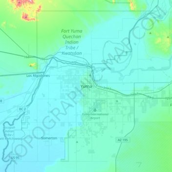
Name: Yuma topographic map, elevation, terrain.

Location: Yuma, Yuma County, Arizona, 85364, USA (32.53266 -114.78762 32.85266 -114.46762)

Average elevation: 226 ft

Minimum elevation: 85 ft

Maximum elevation: 1,667 ft

Gear up for your next adventure:

🏥Hiking First Aid Kits - Comprehensive medical kits for remote trail injuries
🧭Pro Hiking Compasses - High-accuracy liquid-filled compasses for topographic orientation
📶Vehicle Signal Boosters - Improve reception in rural areas while driving to trailheads
🦟Ultrasonic Repellers - Create a bug-free zone at your camp or rest stop
🚑Emergency Bivvies - Heat-reflective sleeping bags for survival situations

As an Amazon Associate, this site earns from qualifying purchases at no extra cost to you.