Geolocate

Pardavila topographic map

Click on the map to display elevation.

About this map

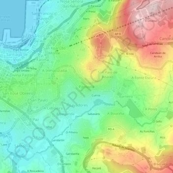
Name: Pardavila topographic map, elevation, terrain.

Location: Pardavila, Vigo, Pontevedra, Galicia, 36214, España (42.21040 -8.71112 42.25040 -8.67112)

Average elevation: 397 ft

Minimum elevation: -10 ft

Maximum elevation: 1,099 ft

Other topographic maps

Click on a map to view its topography, its elevation and its terrain.

Zamáns

España > Galicia > Vigo > Vigo

Average elevation: 1,302 ft

Islas Cíes

España > Galicia > Vigo > Vigo

Average elevation: 10 ft

Navia

España > Galicia > Vigo > Vigo

Average elevation: 66 ft

Beade

España > Galicia > Vigo > Vigo

Average elevation: 614 ft

Sárdoma

España > Galicia > Vigo > Vigo

Average elevation: 210 ft

Illas Cíes

España > Galicia > Vigo > Vigo

Average elevation: 10 ft

Coruxo

España > Galicia > Vigo > Vigo

Average elevation: 423 ft

Candeán

España > Galicia > Vigo > Vigo

Average elevation: 873 ft

Candeán

España > Galicia > Vigo > Vigo

Average elevation: 787 ft

Gear up for your next adventure:

🪵Folding Camp Saw - Compact saw for wood and campsite work
🪶Compact Camp Shovel - Folding shovel for campsite tasks
🪑Portable Camp Table - Compact table for campsite meals
🔌Solar Panel Charger - Charge gear sustainably outdoors
📡Handheld GPS Device - Reliable handheld GPS for outdoor navigation

As an Amazon Associate, this site earns from qualifying purchases at no extra cost to you.