Geolocate

Calangute topographic map

Click on the map to display elevation.

About this map

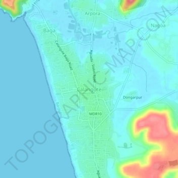
Name: Calangute topographic map, elevation, terrain.

Location: Calangute, Bardez, North Goa, Goa, 403516, India (15.50559 73.72462 15.58559 73.80462)

Average elevation: 43 ft

Minimum elevation: -3 ft

Maximum elevation: 295 ft

Other topographic maps

Click on a map to view its topography, its elevation and its terrain.

Anjuna

India > Goa > Bardez > Anjuna

Average elevation: 46 ft

Pilerne Lake

India > Goa > Bardez > Sangolda

Average elevation: 128 ft

Corjuem Fort

India > Goa > Bardez > Corjuem

Average elevation: 43 ft

Aguada Fort

India > Goa > Bardez > Sinquerim

Average elevation: 26 ft

Anjuna

India > Goa > Bardez

Average elevation: 43 ft

Anjuna Beach

India > Goa > Bardez > Anjuna

Average elevation: 33 ft

Chapora Fort

India > Goa > Bardez > Chapora

Average elevation: 26 ft

Gear up for your next adventure:

🎒Day Hiking Backpack - Lightweight backpack perfect for day trips and outdoor adventures
🗃️Trail First Aid Kit - Essential kit for outdoor injuries and emergencies
🪶Thermal Camp Blanket - Extra warmth for cold nights
GPS Sports Watch - GPS watch for running, hiking and training
🪶Survival Guide Book - Expert advice for emergency preparedness

As an Amazon Associate, this site earns from qualifying purchases at no extra cost to you.