Geolocate

Brdo topographic map

Click on the map to display elevation.

About this map

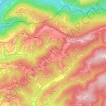
Name: Brdo topographic map, elevation, terrain.

Location: Brdo, Grad Buje, Istria County, 52462, Croatia (45.42957 13.73972 45.46957 13.77972)

Average elevation: 991 ft

Minimum elevation: 180 ft

Maximum elevation: 1,470 ft

Other topographic maps

Click on a map to view its topography, its elevation and its terrain.

Umag

Croatia > Istria County

Average elevation: 23 ft

Bale

Croatia > Istria County

Average elevation: 387 ft

Općina Grožnjan

Croatia > Istria County

Average elevation: 659 ft

Općina Sveti Petar u Šumi

Croatia > Istria County

Average elevation: 1,050 ft

Općina Tar-Vabriga

Croatia > Istria County

Average elevation: 43 ft

Gear up for your next adventure:

🧯Portable Fire Pit - Compact fire pit for camping spots
🧺Microfiber Travel Towels - Compact and fast-drying towels for trail use
🍳Camping Cook Set - Complete cookware for outdoor meals
🥄Camping Utensil Set - Lightweight utensils for outdoor meals
🩹Survival Bandages - High‑quality bandages for emergencies

As an Amazon Associate, this site earns from qualifying purchases at no extra cost to you.