Geolocate

Mexico topographic map

Click on the map to display elevation.

About this map

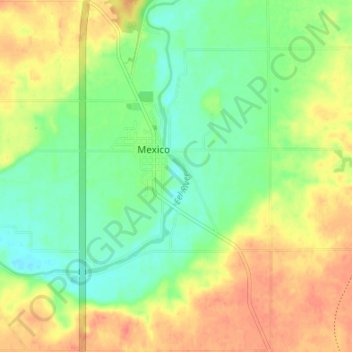
Name: Mexico topographic map, elevation, terrain.

Location: Mexico, Miami County, Indiana, 46958, United States (40.79287 -86.12918 40.84383 -86.09297)

Average elevation: 728 ft

Minimum elevation: 656 ft

Maximum elevation: 804 ft

Other topographic maps

Click on a map to view its topography, its elevation and its terrain.

Loree

United States > Indiana > Miami County

Average elevation: 807 ft

Ridgeview

United States > Indiana > Miami County > Peru

Average elevation: 673 ft

Gear up for your next adventure:

🪵Folding Camp Saw - Compact saw for wood and campsite work
🔊Portable Camp Speaker - Music and alerts at camp
🔭Compact Binoculars - HD vision for scouting terrain and identifying distant landmarks
🛶Inflatable Kayak - Portable kayak for rivers, lakes, and expeditions
🛌Ultralight Sleeping Bags - Compact down bags for cold nights in the wilderness

As an Amazon Associate, this site earns from qualifying purchases at no extra cost to you.