
Thank you for supporting this site ❤️
Make a donation
Make a donation
Gear up for your next adventure:
As an Amazon Associate, this site earns from qualifying purchases at no extra cost to you.
Corano topographic map
Click on the map to display elevation.
Thank you for supporting this site ❤️
Make a donation
Make a donation
Gear up for your next adventure:
As an Amazon Associate, this site earns from qualifying purchases at no extra cost to you.
About this map
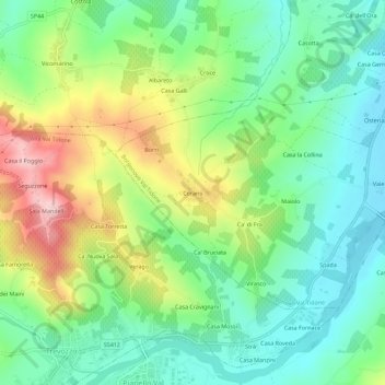
Name: Corano topographic map, elevation, terrain.
Location: Corano, Borgonovo Val Tidone, Piacenza, Emilia-Romagna, Italia (44.94691 9.39244 44.98691 9.43244)
Average elevation: 774 ft
Minimum elevation: 472 ft
Maximum elevation: 1,342 ft
Thank you for supporting this site ❤️
Make a donation
Make a donation
Gear up for your next adventure:
As an Amazon Associate, this site earns from qualifying purchases at no extra cost to you.
Other topographic maps
Click on a map to view its topography, its elevation and its terrain.
Castello di Borgonovo Val Tidone
Italia > Emilia-Romagna > Piacenza > Borgonovo Val Tidone
Average elevation: 354 ft