
Kelab Darul Ehsan topographic map
Interactive map
Click on the map to display elevation.
About this map
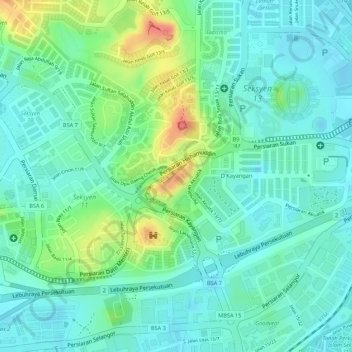
Name: Kelab Darul Ehsan topographic map, elevation, terrain.
Average elevation: 82 ft
Minimum elevation: 16 ft
Maximum elevation: 236 ft
Other topographic maps
Click on a map to view its topography, its elevation and its terrain.
Sungai Buloh
Malaysia > Selangor > Shah Alam
Sungai Buloh, Shah Alam, Petaling, Selangor, 40160, Malaysia
Average elevation: 167 ft
Section 25
Malaysia > Selangor > Shah Alam
Section 25, Shah Alam, Klang, Selangor, 42450, Malaysia
Average elevation: 20 ft
Broken Heart Lake trail
Malaysia > Selangor > Shah Alam
Broken Heart Lake trail, Section U10, Shah Alam, Petaling, Selangor, 40710, Malaysia
Average elevation: 213 ft
Section 36
Malaysia > Selangor > Shah Alam
Section 36, Shah Alam, Klang, Selangor, Malaysia
Average elevation: 26 ft
Section 13
Malaysia > Selangor > Shah Alam > Section 13
Section 13, Shah Alam, Selangor, 40675, Malaysia
Average elevation: 72 ft